
Intra-field zoning of soil cover based on geophysical methods
DOI:
https://doi.org/10.31251/pos.v8i3.338Keywords:
soil cover; intra-field zoning; electromagnetic profiling; ground-penetrating radar; electrical tomography; aerial photography; vegetation indices; ASF index; granulometric composition; soil moisture.Abstract
The aim of the study was to test the application of shallow electrical prospecting methods for intra-field zoning of soil cover of agricultural land.
Location and time of the study. The research was conducted on the fields of Rubin LLC in the Krasnozersky District of the Novosibirsk Region in May 2025.
Methods. The research methods included aerial photography using a Dji Mavic Air quadcopter, electromagnetic profiling using EMS equipment, electrical tomography using Skala equipment, ground-penetrating radar using Oko equipment and analysis of soil particle size distribution and moisture content.
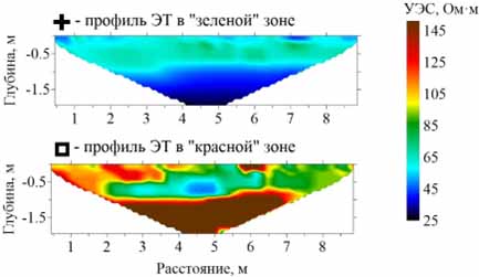
Results. The map of electrical resistivity (ER) distribution, obtained by transforming the EMS signal, showed areas of high and low resistivity. The higher resistivity zones corresponded to elevated relief features, as well as the “red” zones on the map of the average annual vegetation ASF index, i.e. zones with relatively low soil fertility and crop yields. Areas of low resistivity were associated with lower relief features and higher soil moisture. This effect was due to the moisture redistribution on the soil surface after spring snowmelt and heavy precipitation from areas with higher elevations towards lower elevations, as well as the water retention capacity of soils due to their different granulometric composition in the “red” and “green” zones according to the ASF index. There was a strong direct correlation between the ER and the sand fraction content and an inverse relationship with the content of fine-grained fractions. According to the electrical tomography and ground-penetrating radar data for the transitional profile from the “green” to the “red” zone according to the ASF index, there was a gradual increase in ER values and the appearance of a layered structure of sediments underlying the humus-accumulative (A) and transitional (AB) horizons. The latter most likely indicated a sharp decrease in soil organic matter content and an increase in the sand fraction in the granulometric composition of the soils underlying the A+AB horizons.
Conclusions. The use of shallow electrical prospecting and aerial photography methods allows performing the zoning of the soils under ER investigation both horizontally and vertically. Geophysical methods can refine the intra-field zoning of soil cover based on vegetation indices, as well as reduce the field and laboratory (chemical analyzes) studies of soil properties, which, nevertheless, cannot be completely abandoned in order to identify the true causes of soil fertility and, accordingly, crop yields decline in the “red” zones according to the ASF index.
Downloads
Downloads
Published
How to Cite
Issue
Section
License
Copyright (c) 2025 The Journal of Soils and Environment

This work is licensed under a Creative Commons Attribution 4.0 International License.


