
Distribution of Al-Fe-humus soils within the low mountains watershed area in the Middle Urals (using the Basegi ridge as an example)
DOI:
https://doi.org/10.31251/pos.v8i2.294Keywords:
Al-Fe-humus soils; diagnostic horizons; soil classification; tundra; crooked forest; transitional ecotones; landscapes; information-logical analysis.Abstract
The aim of the study. To study the distribution patterns of Al-Fe-humus soils in the watershed area of the low mountains (mountain tundra and goltsy landscapes, crooked forests) in the Middle Urals (within the Perm region).
Location and time of the study. The research was conducted within the undisturbed part of the Middle Ural, i.e. the Basegi Ridge, which is included in the Basegi State Nature Reserve and is located in the eastern part of the Perm Territory, on the western slope of the Ural Mountains (58°45'-59°00' N, 58°15'-58°38' E) in the interfluve of the Usva and Vilva Rivers. The territory is remote from industrial centers. The data obtained in 2009–2020 were used to characterize the soils.
Methods. Al-Fe-humus soils were the object of the study. Comparative-geographical, profile, macromorphological research methods, as well as information-logical analysis were used. Soil diagnostics was based on the presence of the corresponding diagnostic horizon according to the soil classification of Russia. Morphological description of soils was carried out in the field, with some adjustments in the office. Soil samples were selected based on genetic horizons, the color of which was determined using a standard color scale. Information-logical analysis was performed in the ALI program developed in the Altai State Agrarian University, Russia.
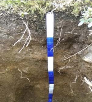
Results. The alphеhumus soils profiles consisted of clearly expressed and well-distinguished organogenic and mineral horizons. Organogenic horizons of varying thickness (from 3 to 15 cm) were present in almost all types of soils. The strength of the relationship between the nature of the horizons (organogenic, mineral) and their color was determined. Diagnostic horizons of soils of the Al-Fe-humus section were visually clearly distinguished: BHF (Podburs), E (Podzols), indicating the main processes of soil formation: Al-Fe-humus, podzolic. Regional morphological and genetic features of soils and diagnostic horizons patterns formation in space were determined: development of the Al-Fe-humus horizon was specific to the harsh conditions of the flattened relief tundra; crooked forests had the most favorable conditions for the formation of the podzolic horizon. Simple profiles (monogenetic) develop in the typical high-altitude landscapes, i.e. in the mountain tundra and crooked forest. Soil polygenesis occurs in transitional ecotones of the tundra-crooked forest (e.g. spruce small forest). Seven types and sxi subtypes of soils of the Al-Fe-humus section were diagnosed.
Conclusions. The distribution patterns of Al-Fe-humus soils in the landscapes of the Basegi ridge watershed are determined by the spatial variability of surface sediments, relief, and vegetation. The altitude of the landscape distribution varied on differently exposed slopes. Accordingly, the change in the soil cover composition of the low mountains watershed occurs depending on the slope exposure. A tendency for the development of of Al-Fe-humus soil subtypes was revealed: under the more humid conditions, illuvial-humus subtypes are formed under a thick organogenic ground cover, whereas under the less humid conditions, illuvial-ferruginous subtypes develop. The watershed soil cover in the low mountains is represented by different types of the Al-Fe-humus soils, which we recommend classifying as zonal soils, i.e. as Podburs in the mountain tundra, as Podzols in the crooked forests, and as Sod-Podburs and Sod-Podzols in the transition zone from the tundra to the crooked forest.
Downloads
Downloads
Published
How to Cite
Issue
Section
License
Copyright (c) 2025 The Journal of Soils and Environment

This work is licensed under a Creative Commons Attribution 4.0 International License.


