
Аgroecological potential of the western part of the Kuznetsk-Salair geomorphological province: digital mapping methodology, geospatial analysis, correlation with soil organic carbon content
DOI:
https://doi.org/10.31251/pos.v6i3.224Keywords:
sum of active air temperatures; humidification coefficient; continentality of climate; soil database; WorldClim; SAGA GIS.Abstract
The aim of the study: to develop a methodology of digital mapping of the agroecological potential (AP) of the western part of the Kuznetsk-Salair geomorphological province and to conduct a comparative analysis of the studied parameter typical for 12 types and subtypes of soils of the studied territory; to conduct a correlation analysis of the relationship between climatic and geographical indicators and soil organic carbon content.
Studied area and method. The studied area occupies the western part of the Kuznetsk-Salair geomorphological province of the Altai-Sayan Mountain country (Russia, Novosibirsk region, Iskitimsky district). The methods of digital mapping, geospatial, correlation and comparative geographical analyses were used in the work.
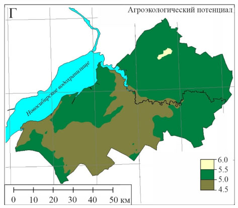
Results. The developed methodology and the use of maps in raster format enabled to identify the pronounced spatial differentiation of the AP, as well as to visualize its spatial change on a digital map. Geospatial analysis showed that AP values varied in the range from 4,5 to 6,0, increasing from the southwest to the northeast of the study area. The change in AP by 0,5 units served as the basis for the allocation of three agro-climatic evaluation subzones. The average AP values, characteristic of the soils, varied in the range from 4,9 to 5,4. The correlation between climatic and geographical parameters (the sum of active air temperatures above 10 °C, the amount of precipitation and evaporation per year, geographical latitude, coefficients of humidification and continentality of the climate) and the organic carbon content were characterized by a moderate and noticeable strength of the relationship.
Conclusions. The conducted research allowed: 1) to develop a methodology for digital mapping of agroecological potential and identify eight agro-climatic assessment subzones; 2) to obtain more accurate information about spatial changes in climatic characteristics; 3) to determine the average values of agroecological potential typical for 12 types and subtypes of soils of the studied territory; 4) to identify the relationship between climatic and geographical parameters and the content of organic matter carbon in soils.
Maps of agroecological potential can be further used for mapping the normative yield of agricultural crops; selection of varieties of crops with certain needs for heat and moisture resources for growth and development; designing adaptive landscape systems of agriculture; assessment of the cadastral cost of agricultural land and the suitability of land for use in agriculture; studying the influence of climatic characteristics on soil and vegetation covers.
Corrigendum. This article was modified due to an error detected the software employed for calculating the correction map for the moisture coefficient. As a result, two maps (moisture coefficient and agroecological potential) and Figure 5 changed significantly.
Downloads
Downloads
Published
How to Cite
Issue
Section
License
Copyright (c) 2023 The Journal of Soils and Environment

This work is licensed under a Creative Commons Attribution 4.0 International License.


