
Mapping of mires of the Tomsk region by the clustering method
DOI:
https://doi.org/10.31251/pos.v8i4.323Keywords:
remote sensing of the Earth; mires; thematic classification.Abstract
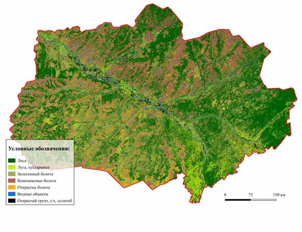
The aim of the study was thematic classification of mire ecosystems in Tomsk Region using Sentinel-2 Earth observation data and the K-means clustering method to improve the accuracy of area estimation and identify local spatial distribution patterns of mires. Spectral bands (2, 3, 4, 8A, 11) and indices (NDVI, NDWI, NDBI) from April to September 2024 were used as predictors and processed in Google Earth Engine. Cartographic visualization was performed in QGIS. Fourteen clusters were identified and grouped into seven classes: forested, open, and complex mires, woody and meadow-shrub vegetation, water bodies and bare soil. The total mire area was estimated as 49.7% of the region’s territory, exceeding previous estimates by 5.4%. The largest discrepancies were observed for forested mires (+9,32%) and complex mires (–5,87%); these discrepancies can be attributed to the high spatial resolution and optimized set of predictors, including the SWIR band for moisture detection. The results confirm the effectiveness of unsupervised classification for delineating homogeneous mire ecosystems. To further improve accuracy, integration of field data, time series, and additional predictors such as texture and morphometric parameters is recommended.
Downloads
Downloads
Published
How to Cite
Issue
Section
License
Copyright (c) 2025 The Journal of Soils and Environment

This work is licensed under a Creative Commons Attribution 4.0 International License.


