
Characteristic features of peat deposits of mountain mires on the western macroslope of the Middle Urals (Basegi Ridge)
DOI:
https://doi.org/10.31251/pos.v8i4.314Keywords:
mountain mires; the Middle Urals; peat deposits; phytocenosis; peat; ash content; moisture; information-logical analysis.Abstract
The aim of the study. To identify the characteristic features of peat deposits of mountain mires of the Middle Urals.
Location and time of the study. The study was conducted in 2018-2022 in the protected area "Basegi State Nature Reserve" (Gremyachinsky Urban District, Perm Territory), which includes the Basegi Ridge (58°45'-59°00' N, 58°15'-58°38' E). The study was carried out within the boundaries of the two catchment funnels in two key areas located on the slopes of the western and eastern exposures of the ridge on the Severny Baseg Mount.
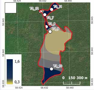
Methods. Peat deposits were the object of the study. The following methods were used: field routes, comparative geography, GIS technologies, indicator links, statistics (descriptive statistics, information and logical analysis), cartographic, geomodeling. Source materials: topographic maps at the scale of 1:25000, prepared using the SAS-Planet program, space images (remote sensing satellites SPOT-6 and ResursP of 14.08.2014 and 27.09.2014) with a resolution of up to 1.5 m. Material processing and data analysis were carried out using GIS MapInfo Professional. Digital maps of the relief, peat thickness in the mire massifs were compiled. Geobotanical observations were carried out in the mire massifs of the Basegi Ridge. On the western slope the study was carried out within the boundaries of three mire massifs, whereas on the eastern slope within one mire massif. Peat deposits (9 pcs. and 3 pcs. respectively) were drilled to collect peat samples at 10 cm intervals throughout the total peat layer. The location of the boreholes was planned taking into account the vegetation cover on the mire mesolandscape along the "center - periphery" line and the main plant formations. Peat samples were analyzed for moisture, ash content, degree of peat decomposition; pH; peat color was determined according to a standard color scale.
Results. The vegetation of the mires was represented by grass-sphagnum phytocenoses. The geobotanical description of the vegetation cover of the mire massifs demonstrated the heterogeneity of the mire biotopes. The mire massifs are shallow, with a low standing of the mire water level (22-50 cm). The thickness of the peat deposit varied from 40 to 150 cm on the western slope and from 180 to 325 cm on the eastern slope of the ridge. The replacement of eutrophic and mesotrophic vegetation by oligotrophic occured first on the mire periphery and then in the central part, which is typical for mire systems formed in highly rugged relief. Mire massifs on the slopes of different exposures differ in altitude, planned configuration of the mire massifs, their size and spatial location. Peat had various shades of brown color (from very dark red to ocher), brownish-black, less often brownish-gray. Within the thickness of the peat deposit, the color of the peat changed, which indicating the change in the main peat-forming plants. A specific peat color was determined for each mire massif. The highest water-holding capacity with the maximum degree of scattering is noted in peat deposits on the periphery of the mire massifs. The ash content of peat varied from low-ash to high-ash. A close relationship was noted between the ash content and the color of peat, especially on the western slope of the ridge.
Conclusions. The vegetation structure of the studied mires is dominated by grass-shrub and moss-lichen layers. The vegetation cover is heterogeneous, since it combines plant communities of different trophicity. The pattern of the mire massif depends on the terrain. High rates of vertical dissection (more than 10 m) combined with a slope provide conditions for the development of a vertical mire (key area 2), otherwise, the mire develops both vertically and horizontally (key area 1). Peat deposits are heterogeneous in color. Peat analysis showed uneven deposits of plant residues, their differences in thickness and degree of decomposition. The degree of peat decomposition varies depending on the depth, in the surface layers being about 25%, gradually increasing to 50% in deeper layers. The studied mire massifs belong to the transitional type by their genesis, by the level of nutrition they can be attributed to mesotrophic. A peripheral-oligotrophic development of the mire systems is observed. Regional and zonal features of peat deposits on the western macroslope of the Middle Urals were determined: the role of the geomorphological factor is significant, which affects different forms of mire massifs on the slopes of western and eastern exposures; the presence of sphagnum (including in lowland peat); high ash content of peats, and especially high ash content of bottom peats. A pattern in the structure of a peat deposit was observed: lowland peat occurs at the base, whereas high-moor peat occurs more often in the upper part of the deposit. Peatland develops from lowland (eutrophic) through transitional (mesotrophic) to high-moor (oligotrophic) type; a change from eutrophic and mesotrophic vegetation to oligotrophic occurs first on the periphery of a mire and then in its central part.
Downloads
Downloads
Published
How to Cite
Issue
Section
License
Copyright (c) 2025 The Journal of Soils and Environment

This work is licensed under a Creative Commons Attribution 4.0 International License.


